Active Fire & Post-Fire Flooding Notice
English
There are active wildfire incidents affecting Southern Colorado, including the Aspen Acres Fire area. Please use official county and incident command sources for evacuation orders, road closures, shelters, animal evacuation, and fire updates.
Apps can be helpful for situational awareness, but official emergency alerts and county information should guide evacuation decisions.
After wildfire, rain can quickly cause flooding, mud, ash, rocks, and debris flows. This can affect roads, culverts, driveways, drainages, low-water crossings, and properties below or downstream from burned areas.
Take action now: sign up for county emergency alerts, keep your go-bag ready, know your evacuation routes, and never drive through water, mud, or debris.
Español
Hay incendios forestales activos que afectan el sur de Colorado, incluyendo el área del incendio Aspen Acres. Use fuentes oficiales del condado y del comando del incidente para información sobre órdenes de evacuación, cierres de carreteras, refugios, evacuación de animales y actualizaciones del incendio.
Las aplicaciones pueden ser útiles para mantenerse informado, pero las alertas oficiales de emergencia y la información del condado deben guiar las decisiones de evacuación.
Después de un incendio forestal, la lluvia puede causar rápidamente inundaciones, lodo, cenizas, rocas y flujos de escombros. Esto puede afectar carreteras, alcantarillas, entradas de vehículos, drenajes, cruces bajos y propiedades ubicadas debajo o aguas abajo de áreas quemadas.
Tome medidas ahora: inscríbase para recibir alertas oficiales de emergencia del condado, mantenga lista su mochila de emergencia, conozca sus rutas de evacuación y nunca maneje a través de agua, lodo o escombros.
Spanish Peaks Alliance for Wildfire Protection
Protecting Wildlife, Families & Homes in the Spanish Peaks Region
Wildfires are a fact of life in the mountains. Preparation saves lives. SPAWP works alongside homeowners, agencies, and volunteers to reduce wildfire risk — so the places we love stay safe.
We’re featured in Target Circle™
Cast your votes to help direct Target funds to SPAWP’s wildfire education and mitigation work. Voting is free for Target Circle members — no purchase or donation needed to help.
How We Help
Three Ways to Take Action
Prepare Your Property
Create defensible space, harden your home against wildfire, and sign up for a free Home Ignition Zone assessment — all with step-by-step guidance.
Get Prepared →See How We Work
Over $1.3 million in grants secured. More than 1,100 acres of forest mitigation. Explore SPAWP's programs and active projects in the region.
Our Programs →Join the Effort
Volunteer for community events, become a Neighborhood Ambassador, or support our mission with a tax-deductible donation.
Get Involved →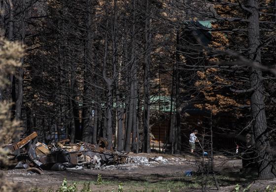
About SPAWP
It's Not a question of If, But When
In the summer of 2018, the Spring Creek Fire scorched over 108,000 acres across Southern Colorado. It destroyed 140 buildings, damaged critical watersheds, and left lasting scars on the landscape and the people who call this place home.
Out of that devastation, our community came together with a clear purpose: prepare for the next fire before it starts. SPAWP is a 501(c)(3) nonprofit working with homeowners, agencies, and volunteers across 7 counties to reduce wildfire risk.
Our Work
Active Projects
SPAWP secures and administers grants that fund critical wildfire mitigation work across the Spanish Peaks region.
Slash Site & Burn Pile Program
Cuchara Valley & Navajo Ranch Mitigation Project
Free Home Ignition Zone Assessments
Getting the HIZ assessment changed how I think about my property. The specialist walked me through exactly what to prioritize — I knew where to start instead of feeling overwhelmed.
— Property Owner, Huerfano County
Stay Connected
Join Our Newsletter
Get wildfire preparedness tips, event announcements, and project updates — delivered to your inbox.
Support Wildfire Protection in the Spanish Peaks
SPAWP is a 501(c)(3) nonprofit. Your tax-deductible donation funds on-the-ground mitigation work that protects our communities, forests, and watersheds.
Our Partners